Meet Patty the Drone and Her Pilots
Research & Inquiry
Flown by students and staff, drones provide a fresh look at campus—with centimeter-level precision.
Photo by Jessica Scranton
Published August 13, 2024
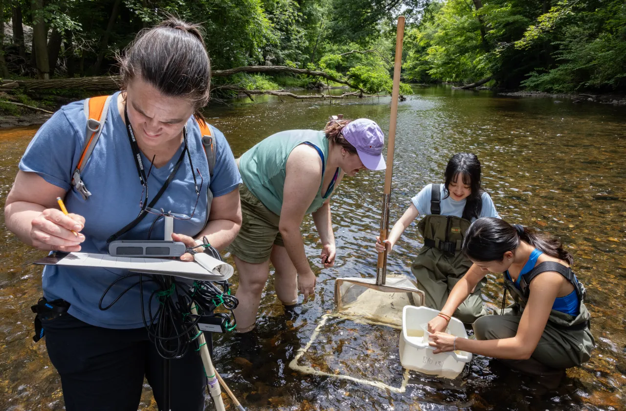
Lia Jacobs ’24 and Kala’i Ellis watch from a gravel path as a small gray drone (nicknamed Patty) lifts into the air and buzzes away over Paradise Pond.
Jacobs is holding a large controller that looks like the bulkier cousin of what someone might use for an Xbox. She eyes the tracking map on the inset screen but doesn’t touch the controls—Patty is preprogrammed for this flight.
“This would have been a good day for sunglasses,” says Ellis, a spatial data specialist with Smith’s Spatial Analysis Lab (SAL), as he squints to watch the drone against the glare of the spring sun. His is a critical job: The Federal Aviation Administration requires drone operators to keep devices like Patty within their sight at all times.
Patty might look as flitting and inconsequential as a sparrow up in the sky, but the purpose of her flight is very specific—to map the pond area of campus down to the centimeter and provide essential data for several research projects, both student- and professor-driven.

Depending on funding, the SAL acquires new DJI-branded drones every two or three years to replace outdated or malfunctioning ones (for various reasons, the tiny fliers occasionally tangle in trees or crash).
Each time the lab gets a new drone, students give it a name that starts with P—a lab tradition ever since the first Smith drone took its inaugural flight at Popham Beach in Maine in 2015. Patty’s predecessors have included Popham, Pademelon, Paul, Pigeon, Pangea, Pika, Pebbles, Plants, Python, and Phippsburg. With Pearsall and Pandemic, students leaned into world events, while the trio of Pioneer, Paradise, and Pond were nods to Smith itself.
As a new model, Patty is outfitted with a filter to reduce the glare from the water. More importantly, she carries a special global positioning system known as “real-time kinematics” (RTK for short), which lets her pinpoint the exact location of each image she records in flight.
In the past, preparing for a drone flight included having researchers like Ellis (and the professors who work with the SAL) walk the entire course of their survey area in advance, placing large orange markers to help them configure the GIS maps they wanted to generate—and hoping that wind or curious passers-by didn’t move them in the meantime.
Patty’s RTK update, which can take photos with extreme precision, means the legwork to add markers on the ground is no longer necessary.
“Generally anywhere on campus now, we can connect [Patty] to the base station and we’re getting—confidentially we can say—centimeter-level precision,” says Ellis, referring to the central tower on Sabin-Reed that Patty communicates with to figure out her location. “And that’s on top of centimeter-level spatial resolution, pixel size.”

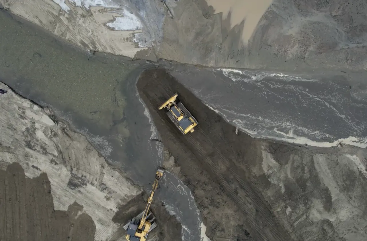
Drones like Patty help staff monitor ongoing campus work, including the geothermal energy project. Photo courtesy of SAL.
For a little over four minutes, Patty travels 3.5 hectares in a precise flight path known as a “lawnmower pattern.” She has company, too. A commercial plane flies overhead, then a military transport, and a glider launched off Mount Tom. “Some friends in the airspace,” notes Ellis.
By the time Patty comes to a buzzy landing on a small, portable pad that Jacobs has placed on the ground, she has captured 2.96 GB worth of data in 307 images.
Back in the lab at a computer station with a view of the pond, Jacobs imports the data and begins to configure her map. She first became interested in analyzing geographic information during a class that taught the widely used mapping software ArcGIS. Jacobs delved more deeply into geographic information systems (GIS) in environmental classes. Then she took a drone class with Ellis and Smith Research Affiliate Jon Caris (SAL’s former director).
Sold on the merits of drone work, Jacobs volunteered to fly Patty once a week during the spring. The frequency was designed around keeping tabs on the geography of Paradise Pond during the college’s annual sediment redistribution efforts. As a data side project, Jacobs also created a map that counted the number of geese at the pond each week.
“I like trying to solidify it in my brain,” Jacobs says of flying drones and mapping the resulting data each week. “Even though I’ve done it numerous times, I still need a refresh.”
More practically, Jacobs, an environmental science and policy major who plans to go into nonprofit work, says that skills in GIS software and drone operation gave her a leg up in her job hunt. “I’m applying to jobs right now and I’ve definitely seen on a few applications ‘GIS skills preferred,’ so then I can check that off,” she says. “I actually used GIS software in my internship this summer.”

Heather Rosenfeld, who started as the SAL’s new director recently, notes that, although drones were created for military applications, they’ve far exceeded those initial bounds and are now key tools for managing conservation, conducting geological surveys, and tracking construction efforts—including the college’s geothermal work—among other uses.
“It’s part of the GIS world in a way that’s grown over the last 10 or so years,” says Rosenfeld.
Rosenfeld, whose background and expertise lie in the environmental science and policy side of the lab’s work, undertook their first drone flight in August, shortly after starting their new director position.
And which drone served as their first flying buddy? Of course, it was the keen little craft known as Patty.